
Mountain Directory is great for anyone driving in the mountains, especially for semi truck drives and vehicles pulling large campers. It doesn’t matter whether you are going up the mountain or down the mountain it can be very dangerous if you don’t know what’s ahead.
FOR ANYONE DRIVING A LARGE OR HEAVY VEHICLE
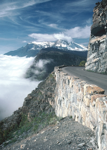
In an attempt to make mountain driving a little safer for truckers and RV’ers, R&R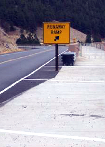 Publishing Inc. has been collecting and publishing information about mountain passes and steep grades since 1993.
The Mountain Directory Ebooks give the locations and descriptions of over 700 mountain passes and steep grades in 22 states.
The Mountain Directory ebooks tell you where the steep grades are, how long they are, how steep (%) they are.
whether the road is two lane, three lane, or four lane, if there are escape ramps, switchbacks, sharp curves, speed limits, etc.
With this information, one can know ahead of time what a pass is like and make an informed decision about whether to go over or around.
MOUNTAIN DIRECTORY AND MOUNTAIN PASSES
If you decide to go over, perhaps the cool morning hours would ease the strain on the engine and transmission during the climb. Unhooking the towed vehicle would make the climb and the descent easier. Knowing what lies ahead is half the battle.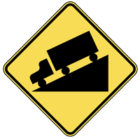
The printed versions of the Mountain Directory books had almost 240 pages of text and color relief maps. All 240 pages are in the downloadable versions of the Mountain Directory ebooks.
Nothing is missing. In the printed versions, mountain pass locations were marked with a yellow triangle on the color relief maps.
In the ebook versions, you can click on the yellow triangles and the text appears that describes that location.
Mountain Directory and Grades
 A large percentage of the grades in the western states are in the 6% range.
A large percentage of the grades in the eastern states are 8, 9, or 10% and sometimes even more. The eastern grades are often shorter but this is not always so.
A quick glance through the eastern book will reveal over 50 grades that are between 7 and 10% and from 4 to 7 miles long.
MOUNTAIN DIRECTORY AND CHALLENGING ROADS
There are others that are even more challenging. The road to the top of Whiteface Mountain in New York is 8 to 10% for 8 miles.
There would be no need for truckers to use this road but RVs are allowed. Near Cumberland, Maryland there is a hill on I-68 that is posted as 6% for 13 miles.
In North Carolina highway 181 crosses the Blue Ridge Parkway and the southbound descent is 11 miles of grade that varies from 6 to 10%. Much of it is 8 to 9%. These grades are just as hazardous as the grades in the western states.
From the Colorado section of the Mountain Directory West:
VAIL PASS elev. 10603′ (on I-70 east of Vail, CO)
The descent on the westbound side of Vail Pass is about 10 miles in length and begins at milepost 189 on I-70. One half mile west of the summit there are warning signs for westbound traffic-
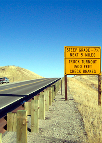
–“Speed limit 45 mph for vehicles over 30,000 lbs.” and “Steep grade next 8 miles–trucks stay in lower gear.” The next mile is rolling hills. Then there is a sign–“7% grade next 7 miles.”
The descent is steady at 7% and there are 3 advisory signs for the first runaway truck ramp which is about milepost 185 or 4 miles down from the summit. The escape ramp is upsloping on the right.
The second runaway truck ramp is about milepost 182, which is 3¼ miles after the first escape ramp, or about 7¼ miles down from the summit. There are several advisory signs before reaching it and it is an upsloping ramp on the right.
Don’t be fooled when the grade eases after the second escape ramp. It soon goes back to 7% and doesn’t bottom out until 2½ miles after the second escape ramp or about milepost 179.
MOUNTAIN DIRECTORYThe eastbound descent from the summit of Vail Pass continues almost to the Frisco exit about 11 miles down the hill but the descent is not steady. There are short steep sections followed by short sections of lesser grade. The last half of the descent is 3-4% grade. There are no escape ramps on the east side of the pass.
 In most cases the passes and hills are described as descents.
This directory does not claim to include every steep grade. In fact, because of the enormous area we have tried to cover, we can guarantee that we have probably missed some.
Sometimes the percentages quoted are estimates.
This book does not attempt to rate passes or grades according to difficulty. There is an enormous variety in vehicles and equipment.
MOUNTAIN DIRECTORY’S PURPOSE
 The purpose of this book is not to discourage drivers from going where they please.
It is only to inform them of the conditions they may encounter and to encourage them to make sure their equipment is in good repair.
The engine’s cooling system should be in good repair to prevent overheating during the climbs. Turning off the air conditioner during climbs may help, and if necessary, turning on the heater will help dissipate heat from the engine.
From the North Carolina section of the Mountain Directory East:
I-40 (between Black Mountain and Old Fort, NC)
The grade is posted as 5 miles of 6%. It is a strong 6%. There are three runaway truck ramps, all of which are short sand beds with sand piles at the end. The westbound descent is about 1¼ mile of 6%.
AFTERMARKET DEVICES
There are many aftermarket devices that can help heavy vehicles in the mountains. Some will help by increasing horsepower for the climbs. These include turbos and exhaust systems.
Other devices, such as engine braking systems can help during the descents. Some products, like gear splitters and auxiliary transmission can help during the climbs and descents.
The main ingredients involved in overheated brakes are the length of the grade, the steepness of the grade, and the speed and weight of the vehicle. Reducing any of these will improve the chances of getting down the mountain without overheating the brakes.
Most of the time, the only one the driver can change is speed. Reducing speed may keep you alive. Remember the old phrase, “You can go down a mountain a thousand times too slowly, but only once too fast.”
Introducing the Mountain Directory Ebooks!
Try it before you buy!
Check out this free demo and see how it works.
CLICK HERE FOR FULL DETAILS
Travel with safety – safety from knowledge and information about navigating through the Mountain Grades and Terrain.
